This analysis and commentary will address 12 points why I perceive what happened on Monday 08 Nov 2010 was the launch of a ballistic vehicle off the coast of Southern California, from the presumption of non-US launch and the more probable US launch. An assessment of my personal interpretation addressing the various issues with the vehicle and the lack of much publicly available recorded radar, ISR data and other imagery, in addition to the basic opposability that dedicated resources may not have been looking in the necessary direction in advance, implementing more appropriate instrumentation.
To start, I am an avid observer of all things and former US Navy weapon systems technician (Weapons Fire Control) and operator, one that stayed close to the defense sector. As such, have witnessed firsthand Terrier, Minotaur, Atlas, Delta, Titan and other launches including last Friday's launch of the Delta II from Vandenberg, and from what I can determine from the news video looks very much like a solid fuel rocket or missile launch.
i) SKY CONDITIONS
On Monday, I was briefly outside looking at the sky and cloud cover not much before this mystery and possible launch event occurred, noticing Jupiter and that the aircraft over head in the sky at the time were not producing contrails of any lasting nature or great size, if at all. All of which, motivated by the early sunset as day light savings time ended this past weekend.
[1]
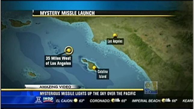
(Fig. 1) Apparent launch location per CBS New 8, Los Angeles California (08 Nov 2010).
ii) APPARENT SEA LAUNCH (per video)
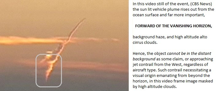
The still frame image collected from KCBS news video,[2] (Fig. 2) clearly shows that the launch vehicle departure point and plume origin is forward of the background atmospheric haze on the vanishing horizon, in addition to the high altitude cirrus clouds. The exact horizon obscured by clouds and earth shadow of a more distance, horizon visibly projected upon the background clouds, the sun having already set. The object penetrating and lifting from what appears to be near ocean surface much like a sea launch ICBM. Since the event occurs forward of the high altitude clouds, ipso facto, that this object is not that of a stratospherically placed approaching inbound jet, irrespective of aircraft type, flight path and ultimate destination (Fig. 3).
With further examination of the video, can identify what appears to be a momentary vertical accent phase, normal to the ocean surface followed by a "role maneuver". Suggesting from the viewer's perspective, a vertical launch orientation for the vehicle and not horizontal or incline such as that resulting from a torpedo tube such as that used for a sub launched Tomahawk missile. Thus, the vehicle seen producing a short and clean vertical accent, void of any substantive departure incident angle relative to the water surface.
[3]
(Fig. 2) Note how the sun (already set) lit vehicle plume rises out from near the ocean surface, and forward of the vanishing horizon, background haze, and high altitude alto cirrus clouds. Hence, the object in question cannot be in the far distant background as some have claimed, or an approaching jet contrail from the West, regardless of aircraft type. Such contrail vectoring in from the west, such as a commercial jet from Hawai`i necessitating a visual origin emanating from below the horizon, in this image masked by high altitude cloud. The long time duration of the plume, and the contrail's general persistence, suggesting that the plume was the product of a solid fuel reaction, and not that of a typical jet contrail.
[4]
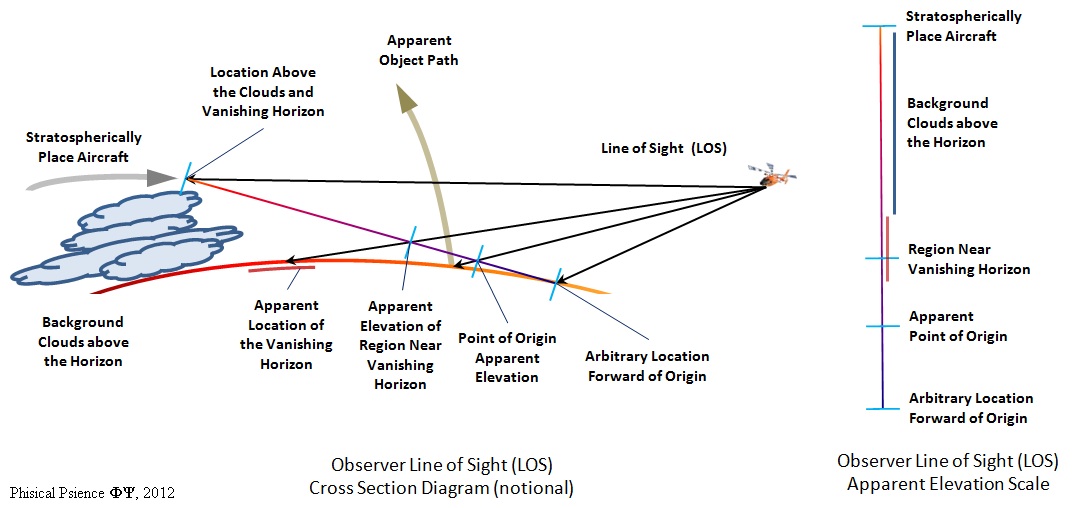
(Fig. 3) The above cross section diagram (left) shows the apparent line of sight (LOS) from the observers reference point (notional, and not to scale) along with the apparent elevation scale (right) with hash marks for i) relative line of sight elevation to an arbitrary location forward of the apparent point of origin ii) the LOS elevation of the apparent point of origin on the surface of the ocean, iii) the slightly ambiguous LOS to the region of the vanishing horizon and iv) the LOS to an elevation position above the background clouds, and location rear of the vanishing horizon. Any incoming aircraft approaching from the west needing to be located at a height sufficiently above the opaque background clouds above the horizon in order for the aircraft's contrail to be visible from the observer's reference point.
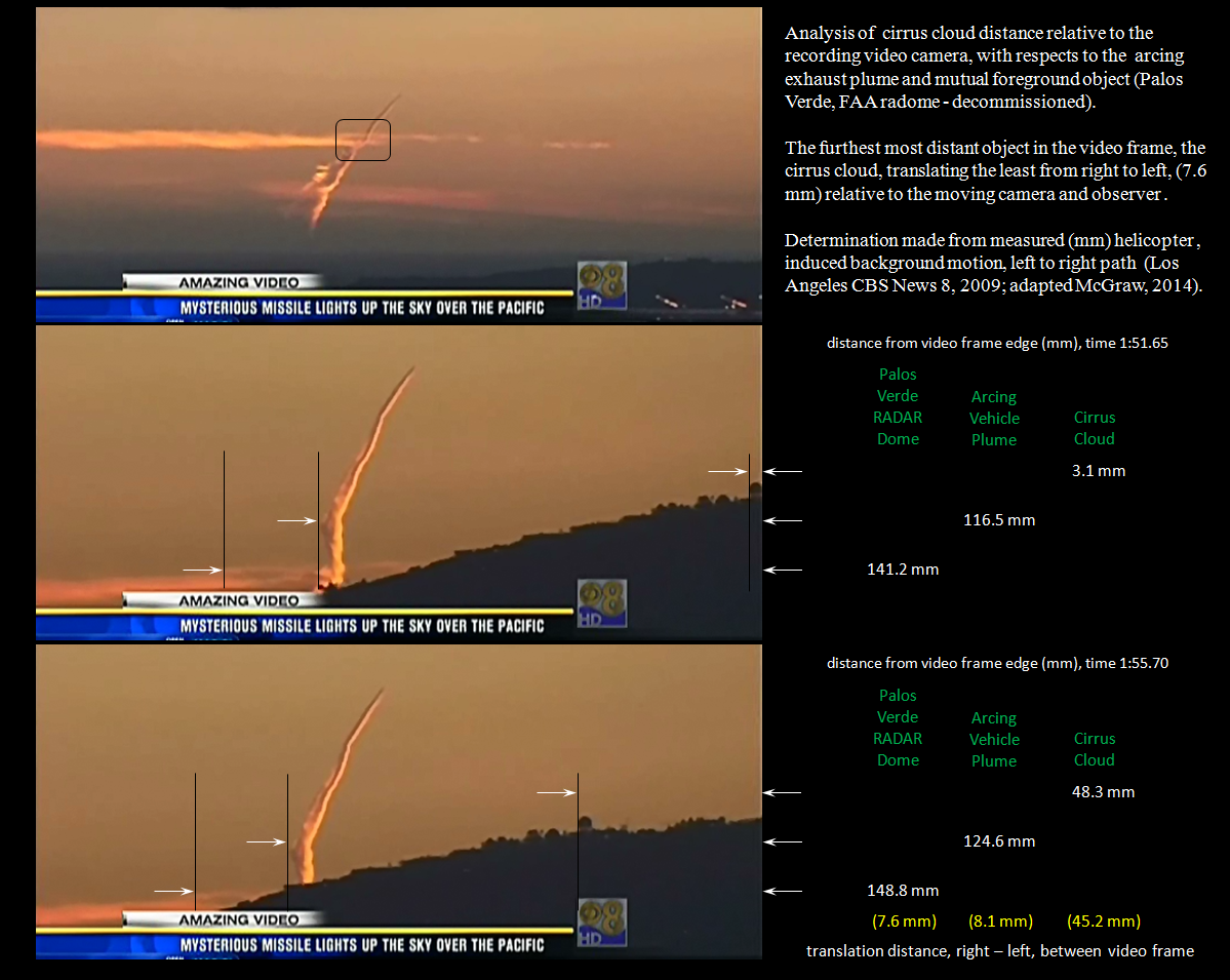
Analysis of background motion, per still frames collected from the Los Angeles CBS New 8 video (Leyvas, 2010; adapted, McGraw, 2014)(Fig. 4), indicating that the arching plume is forward of the horizontal alto cirrus cloud. The cloud, with a 7.6 mm translation, moving the least relative to the plume with an 8.1 mm translation and common location forward to both objects, the decommissioned Palos Verde FAA RADAR Dome with a translation of 45.2 mm.
[6]
(Fig. 4) ...
iii) LAUNCH DIRECTION
Judging from the orientation of the exhaust plume, relative to the direction of the already set sun and position of shadow line along the length of the plume (Fig. 5) does not suggest that this light from the rear of the vehicle is a reflection from the sun. Instead, that this light is the product of a very energetic chemical reaction. The width of the plume, relative to the length of the plume's path and apparent velocity of the vehicle strongly suggest that the combustion rate is magnitudes greater than that of a jet aircraft.
[5]
(Fig. 5) Note how the non constant radius exhaust plume is uniformly illuminated from below (relative angle), and how the placement of the shadow line, and intensity of the shadow line appears nearly invariable. Suggesting that the bearing angle of the plume remained confined for the length of the plume. The even illumination being along the starboard side of the plume, as the plume path is non linear, having a highly pronounced curved path along the vertical geometric plane (x, z), the horizontal plane defined as (x, y), being an indicator that the plume bearing direction is aligned relatively close to the direction of the setting sun in the west. Thus the vehicle was not travelling from the west-southwest moving towards the east, as proposed by some, but instead, the object vectoring towards the west, and receding from the California coast line.
[6]
(Fig. 6) Example of wind shear in the Los Angeles basin, along the atmospheric inversion layer from ~6,000'-8,000' feet. Horizontal wind shear, primary left, secondary right (black arrow) acting upon a evolving smoke plume over the 1,625' ft Mt. Hollywood[7] (Griffith Park fire), ~7.8 miles away, near the atmospheric inversion layer, in this image ~6,000 ft (UCLA, Mt. Wilson Observatory Tower Cam, 09 May 2007 from 00:21:52 to 00:35:13). Note how the portion of the smoke plume below the inversion layer is moving to the left (~south), relative to the image, where as the portion of the plume above the inversion layer is moving slightly to the right (~north).
[8]
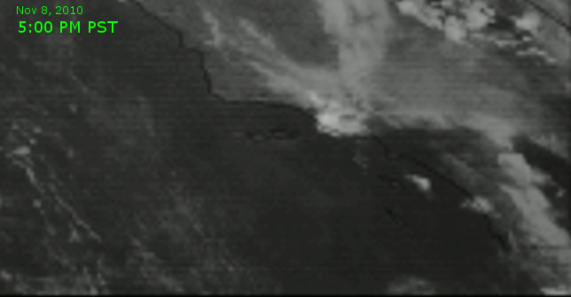
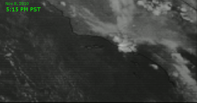
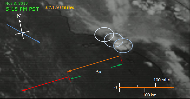
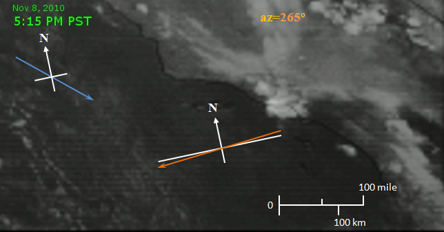
(Fig. 7) Still animation sequence of the mystery vehicle's flight path as recorded from the NASA GOES West satellite, 1 km resolution (NASA, 2010).[9] The first indication of the contrail plume appearing at 5:15 PST though not sufficiently dispersed in width by the winds to appear as a continuous path by the imaging sensor. By time 5:30 the contrail plume is very pronounce, drifting towards the southeast.
[10]
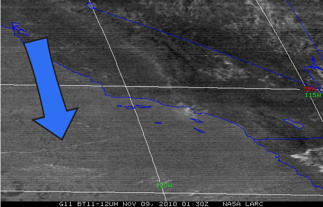
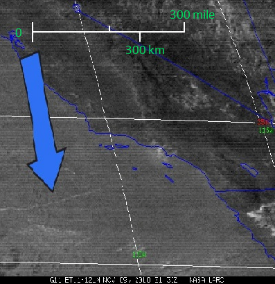
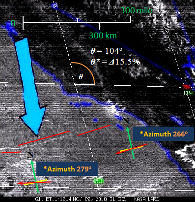
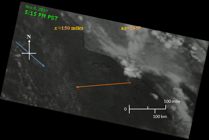
(Fig. 8, left) Infrared image of the Pacific Ocean region off the coast of southern California, northwest Mexico taken at 5:30 PST, as seen from the NASA LARC satellite (NASA, 2010; adapted, xxxx, xxxx; adapted, McGraw, 2014).[11] The central longitude line representing 35o North, the central latitude line being 120o West. Each degree being 60 nautical miles.[12] (Fig. 9, center) NASA LARC satellite image compensated for longitude distortion (NASA, 2010; adapted, xxxx, xxxx; adapted, McGraw, 2014), resulting in unity aspect ratio for the local field of view. (Fig. 10, right) Contrast enhanced image (NASA, 2010; adapted, xxxx, xxxx; adapted, McGraw, 2014) with the principle vehicle path segments noted with three red lines, in addition to course bearing. The vehicle departing along a heading of 265o degrees, altering course to 280o degrees about 300 miles away from the approximate launch point.[13] and in the general direction of Hokkaido Japan or trisection region of North Korea, China and Russia.
iv) VEHICLE VELOCITY
The vehicle, as seen in the video, leads one to believe that the vehicle is travelling at velocities much greater than what a non hypersonic or super sonic aircraft is capable of achieving. This is deduced from the size of the "gilt" of light, at minimum intensity, from what appears to be the rear of the craft relative to the size of the expanding plume immediately aft of the craft.
In addition analysis of meteorological satellite images of the event (Figs. 11-26), the plume of the craft being visible in several frames along with cloud features to aid in determining wind direct, resulting in the vehicle traveling approximately 150 miles in less than 6.5 minutes with an average velocity, (vavg) of just over 1,385 miles/hr (2,227 km/hr) or mach (1.82). The maximum velocity, (vmax), of the object at the end of the 6.5 minutes perhaps in excess of 2,500 miles/hr (4,023 km/hr) or mach (3.28).
(Fig. 25, left) .... (NASA, 2010; adapted, xxxx, xxxx; adapted, McGraw, 2014).[44] (Fig. 26, right)The calculated average velocity (vavg) for the flight being in excess of 1,385 miles/hr (2,227 km/hr). Thus the maximum velecity is considerably higher, perhaps eceeding 2,500 miles/hr (4,023 km/hr)(NASA, 2010; adapted, xxxx, xxxx; adapted, McGraw, 2014).[45]
v) VEHICLE ALTITUDE
The vehicle altitude over the course of the video seems to be increasing at a very rapid rate. A rate of climb that looks to greatly exceed 10,000' ft/min. A rate far greater than any commercial aircraft would attempt to perform but under extreme conditions on the order of an emergency evasive maneuver. The extent of the vehicles upward climb is seen in the changes in the exhaust plume shape as the vehicle traversed the various atmospheric inversion (a.k.a. thermocline layers).
vi) UNIQUENESS
In addition, if the object in question was an airplane, the contrail seen would not have been the only contrail forming, and populating the sky. At one point of the plume path, and difficult to visually determine, appearing to have a slight cork screw component in addition to the primary exhaust plume, and depending on design, could possibly part of a stabilization function.
vii) FAA PROCEDURES
Civil aircraft with that altitude profile file a FAA flight plan, and all classified missions I have been involved with included notifying the FAA to clear civil traffic and because of DSP satellites, NORAD.
What was the transponder frequency of the this so call "airplane"? For to make such claim should be followed with discrete, aircraft specific information along with GPS data to support the exact location and path of the aircraft for concurrence with recorded video imagery.
viii) COMMERCIAL FLIGHTS
The "airplane" as it is being called, also was not on any standard flight path for the Southern California area or departing from any known civilian or military airfield. The video, indicating that this vehicle did not depart from San Nicolas Island. A very easy to make determination supported by the local media pointing out the general location of the event, and news helicopter pilot's report.
As a person that use to fly the local skies out of Long Beach and Camarillo, am aware of the fact that planes approaching or using FAA SoCal approach, do not generally vector in from the direction, or manner seen. That flights coming in from Hawai`i, and Asia, typically the only flights to approach the LA area from the Pacific Ocean, heading to LAX or destinations beyond such as Phoenix and Dallas, also take a different path, and course as seen by the object in the video. The vehicle heading, relative to the setting sun, had it been a commercial aircraft, appearing more like an Asia, or Pacific Northwest bound flight.
ix) RADAR
Typical FAA field radar, because of the nature and age of their design as seen from multiple disciplines, would more than likely, not have seen the object in question. That a weapons fire control search radar, something similar to a AN/SPS-48 or AN/SPY-1 using much higher frequencies, PRF (Pulse Repetition Frequency), yielding greater spatial resolution with less beam divergence, and higher energy levels on target would be required to see such small object at distance, using a realistic Line of Sight (LOS). Especially if the vehicle in question was specifically designed to have a low RF detection signature, such as radar cross section, (RCS) thus requiring a high power illuminating radar with very low signal to noise such as an SPG-60 or SPG-62.
That the missile, with a launch point over 35+ surface miles away or greater, not LOS distance from LAX and increasing, would from ground clutter, possibly not be visible on a simple medium range radar when the vehicle's RCS was at its maximum, near the ocean surface, prior to the start of the vehicle's role maneuver. Had the object departed from a distance near the surface approxiamately 35-75 miles, for that portion of the radar's field of view would have been eliminated by design to reduce RF (radio frequency) backscatter and ground clutter. That by the time the vehicle was high enough in the sky, relative to the LAX radar sites LOS, may have been approaching the vehicle's minimum RCS, seeing only the aft section of the craft.
A more simple explanation for the lack of RADAR and sensor data, dismissing hostile action from a foreign country, is that sensor data was collected by the Department of Defense and various groups, but for the sake of consistency with the "non-U.S. involvement" cover story, released to the press, and perhaps less so, to mask work performed by a visiting nation, leasing the facility, obscured from public view.
The same issues may apply, if even visible in terms of LOS, to the other neighboring airfield such as Oxnard. Plus these locations would also have to deal with the velocity of the vehicle. From an egress perspective, perhaps above the maximum measurable target velocity for the low requirement search radar units. As illumination time on target as a function of the radar units PRF and signal processing become critical factors. Hence the apparent non detection as disclosed by the DoD and FAA by their radar systems. More plossible, RADAR data was collected and not shared.
x) NON U.S. INITIATORS
Presuming no foreign entity is responsible for this event, looks similar to an SLICBM (Submarine Launched ICBM). Since all non small arms live weapons, and fire control operations on a US Navy vessel involves the crew being at "general quarters", makes it highly improbable that this event was unscheduled by the US Navy. Hence, should this event not have been precipitated by the US Navy from a vessel at sea, nor some other US armed service or agency, and or military contractor is involved, then this apparent missile launch does have me very concerned, seeking more answers.
xi) CANDIDATES
Should this event not be the product of the United States of America, would have to wonder if what took place near Los Angeles on Monday, 08 Nov 2010, was a test, from a sensor perspective, of a low signature, low RF observable SLICBM launch from a quite platform by a foreign nation, post sunset for greatest dramatic effect, to publicly demonstrate to our leaders a new capability. Presently, as the US Navy submersible and surface forces, having shrunk over the years, and still shrinking, are not prioritized or have the physical numbers in noisy waters, and shipping lanes to tightly protect the coastal USA for stealthy submersibles and air vehicles every minute of every day. The launch event, conspicuously coinciding with the Presidents departure from the USA for a series of foreign visits. (addition, Jan 2013) The display of weaponry not much different in nature than the timely first test flight of China's first generation stealth fighter aircraft while the US Defense Secretary Mr. Gates was visiting Beijing.
Something a country like China and its military, the PLA, would make note of, judging from public comments and recent publications coming out of China's defense community and leadership. Hence, may consider and be brazen enough to test a new weapons platform in "international waters" near the continental USA. And as followers of Sun Tzu, would not necessarily take credit for the event, at least not yet, leaving such event estrange, to prosper from the powers and shadow of the unknown instigator. For to share the knowledge now may not provide the greatest political or more important, military leverage. Performing such act while Mr. Obama is out of country being a tremendous morale booster for the PLA and nationalist citizenry.
xii) U.S. INITIATOR
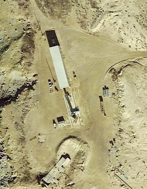
Limiting the complexity of the event, independent of Department of Defense press release reports relative to US involvement, a sort of Occam's razor approach to the analysis, leading one to strongly suspect that the mystery launch vehicle was indeed a product of and initiated by the U.S. The "mystery" vehicle lifting off from a launch pad (Fig. xx) operated by a collective located on or from a surface vessel near San Nicolas Island (Fig. xx), one over sighted by the United States Navy and located some 75 miles west, south west of Los Angeles. The helicopter news report being correct in indentifying the event as a missile launch, however and perhaps because of atmospheric obscuration at low elevation angles, being near the ocean surface, having not occurred at the then reported under estimated distance of 35 miles, being short some 40 miles to the object. The additional sight distance to the launch location and forming exhaust plume, accentuating the apparent slow moving nature of a high velocity vehicle.
[xx][xx]
(Fig. 29, left) Launch pad facility, United States Naval Auxiliary Air Station, San Nicolas Island (Google, and Terra Metrics, 2014; adapted, McGraw, 2014).[xx] (Fig. 30, right)Google map image of region around the Naval Auxiliary Air Station, San Nicolas Island (left of center) the black object at far right being Salton Sea, Vandenberg Air Force Base being along the coast near top, San Diego and Tijuana Mexico being along the coast at bottom right (Google, and Terra Metrics, 2014; adapted, McGraw, 2014).[xx]
The launch event, given the time being so near sunset, thus having very high visibility profile to ground observers, most odd and out of character for the United States of America to disavow any involvement with such military operation, irrespective of simultaneous travels being taken by the Executive Branch.
[50]
[51]
(Vid. 1, 12.1MBtop) KCBS News 8, Los Angeles California video report (KCBS Los Angeles, 2010)[52] of possible ballistic missile launch along with an interview with Mr. Robert Ellsworth (former Deputy Secretary of Defense), 08 Nov 2010, in support of such ballistic missile launch theory, and to which this analysis is in concurrence. (Vid. 2, bottom) CBS News, Washington D.C. report of the possible missile launch (CBS Washington DC, 2010)[53] which this analysis strongly disputes. The report from Washington D.C. suggesting that the plume produced during the recording of the event was that of an aircraft contrail, and not possible for the reasons stated above. (From at least 2014, the video has been removed from the CBS Washington DC bureau website).
[1] Still frame image, Gil Leyvas cm, KCBS 2 / KCAL 9 News, Los Angeles, CA, retrieved 03 Mar 2012; http://losangeles.cbslocal.com/2010/11/09/exclusive-raw-video-mysterious-missile-launch-off-california-coast/, 08 Nov 2010; adapted Park McGraw, 2012.
[2] Still frame image, Gil Leyvas cm, KCBS 2 / KCAL 9 News, Los Angeles, CA, retrieved 03 Mar 2012; http://losangeles.cbslocal.com/2010/11/09/exclusive-raw-video-mysterious-missile-launch-off-california-coast/, 08 Nov 2010; adapted Park McGraw, 2012.
[4] Still frame image, UCLA Mt. Wilson Tower Cam, 09 May 2007 from 00:21:52 to 00:35:13; http://obs.astro.ucla.edu/towercam.htm, adapted by Park McGraw, 2012.
[5] Still frame image, KCBS News 8, Los Angeles CA, report and Robert Ellsworth interview of possible missile launch, 08 Nov 2010, Gil Leyvas cm, (KCBS 2 / KCAL 9 News, Los Angeles, CA), Mystery missile launch occurs over Southern California, 09 Nov 2010, Rocketry Planet, Planet News, retrieved 03 Mar 2012; http://www.rocketryplanet.com/images/stories/2010/3448/KFMB_mystery_missile.flv.
[6] ... , 08 Nov 2010...
[7] Video, KCBS News 8, Los Angeles CA, report and Robert Ellsworth interview of possible missile launch, 08 Nov 2010, Gil Leyvas cm, (KCBS 2 / KCAL 9 News, Los Angeles, CA), Mystery missile launch occurs over Southern California, 09 Nov 2010, Rocketry Planet, Planet News, retrieved 03 Mar 2012; http://www.rocketryplanet.com/images/stories/2010/3448/KFMB_mystery_missile.flv.
[8] Video, CBS News, Washington D.C., report of the possible missile launch, 09 Nov 2010, Mystery Missile Launch Seen off Calif. Coast, Gil Leyvas cm, 08 Nov 2010 (KCBS 2 / KCAL 9 News, Los Angeles, CA), CBS News, retrieved 03 Mar 2012; http://cnettv.cnet.com/av/video/cbsnews/atlantis2/cbsnews_player_embed.swf.
 [1]
[1]
 [3]
[3]
 [4]
[4]
 [6]
[6]
 [5]
[5]
 [8]
[8]
 [10]
[10]
 [14]
[14] 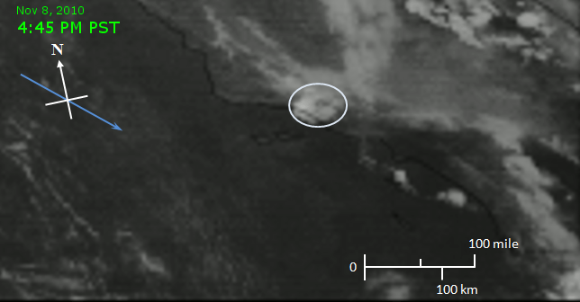 [15]
[15]
 [18]
[18] 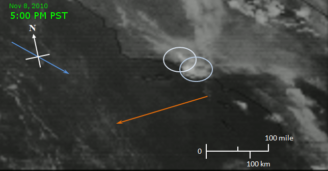 [19]
[19]
 [22]
[22] 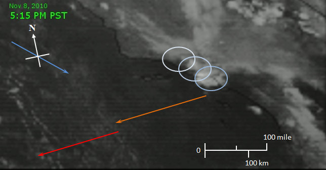 [23]
[23]
 [26]
[26] 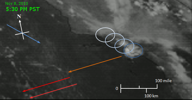 [27]
[27]
 [30]
[30] 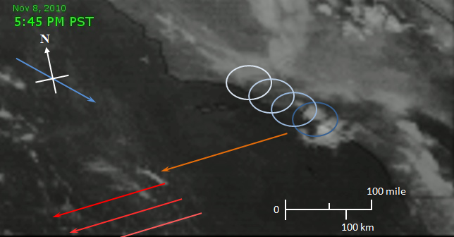 [31]
[31]
 [34]
[34] 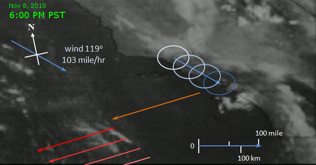 [35]
[35]
 [38]
[38] 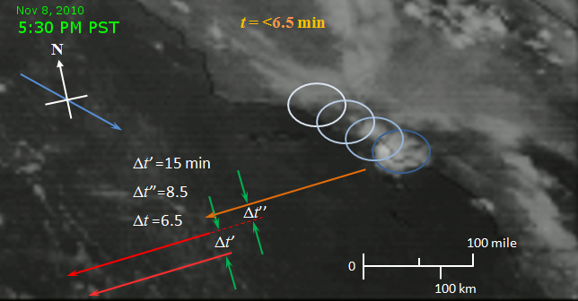 [39]
[39]
 [42]
[42] 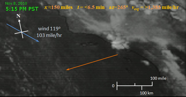 [43]
[43]
 [46]
[46] 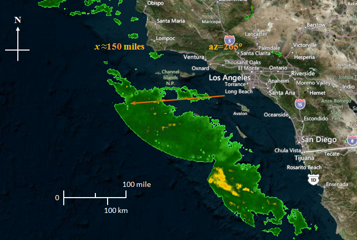 [47]
[47]
 [xx]
[xx] 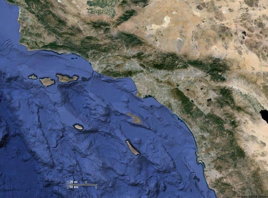 [xx]
[xx]