Possible 6,000 Year Old Summer Solstice, Midnight Backlighting of Mount Denali as seen from Anchorage Alaska
(anticipated full release, summer 2016)
The region surrounding Anchorage Alaska is understood by researchers to have been occupied by humans for the better part of 6,000 years.[1] This area of Alaska situated along the upper tip of Cook Inlet, near the vicinity of the Kink Arm intersection, extending north between the Yentna River along the western boundary and Susitna River along the eastern boundary having a fairly smooth geographic topography, void of major hills and or mountains to interfere with views towards the North North West.[2]
This direction being in direct line of sight of the geologically pronounce Mount McKinley massif nearly 135 miles (217 km) away from Anchorage.[3] The massif being composed of the following principle peaks as seen from Anchorage, Mount Denali (Mt. McKinley) 20,237' ft (6,168 m) the near equally distant Mount Begguya (Mt. Hunter) 14,573' ft (4,442 m) and Mount Foraker 17,400' ft (5,304 m) along the south east flank of Mt. Denali (Fig. 1).[4] An individual in this region of south central Alaska, on clear days being provided with an expansive view of these distant mountains, and one of the longest viewable terrestrial baseline path in North America, if not the longest, easily extending another 100 miles (160 km) past Anchorage.
The baseline being so great in length, the clear line of sight along the downhill sloping terrain to the mountains South South East, providing the viewer much flexibility in their precise location along the Cook Inlet region, yet still experience nearly unobstructed views of Mt. Denali, all of which with similar compass bearing. Thus the total angular deviation for the direct sighting of Mt. Denali being a relative small +/- 15o degrees over the entire viewing region. Therefore, the mountain appearing to sit on the distance horizon with a fairly fixed viewing direction for all viewers in the region. The available area for unobstructed viewing of Mt. Denali covering and estimated 450+ square miles (1,940 sq km) (Fig. 2).
The viewable summer solstice back lighting event, because of Earth's precession of its tilted (obliquity) rotational axis, being of greater time duration today, the Sun being closer to the horizon as it passes beneath Mt. Denali. This event, and at times very dramatic in appearance, being not a single day event, but one viewable near solar midnight for the better part of 6 weeks, weather permitting and highly dominating factor. The duration of time for the event, perhaps shortened to less than a 4 weeks 6,000 years ago (Vid. 1).[5] The event, being the magnificent backlighting of Mt. Denali (Mt. McKinely massif) for an approximately 1 hour prior to and 1 hour post local celestial midnight (anti Earth point) or (anti meridian). The peak of Mr. Denali today, in terms of azimuthal bearing alignment with respects to the celestial north pole (anti-meridian), being about 50 minutes early. The peak being off by about 30 minutes 6,000 years ago, as seen from Anchorage.[6]
The fact that Mt. Denali may have been off by such time, perhaps not of great relevance compared to the overall greater experience of viewing the near midnight backlighting of the mountain. The people of the era, perhaps having an affinity for the summer time even, being that the sun is very low on the horizon during the winter appearing to be moving more slowly relative to the ecliptic, hence more difficult to visually determine the time of seasonal (orbital) change. Furthermore, the region near Cook Inlet is typically covered in cloud cover during the fall to spring period of the year, the Sun having fewer average days of visibility, local being difficult to determine, hence the unusual nature of observing the summer solstice at midnight perhaps of greater social importance than the winter solstice. Therefore, given the number of variables, the summer solstice event, still a chance observation because of weather patterns in the region, perhaps offering greatly improved opportunities to mark the end and start of Earth's orbital induced seasonal cycles.
The region around Anchorage, and simply speculating, perhaps signaling to onward travelers in the area when it was most safe to proceed back to Asia or head deeper into the North America continent, safely regulated via the timing of midnight viewing of Mt. Denali.
[7]
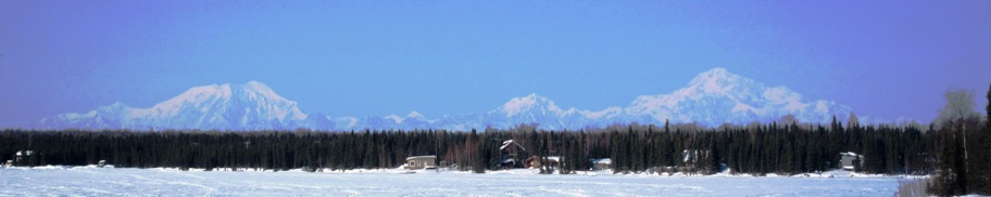
(Fig. 1) Photo looking towards Mount McKinley massif as seen from Lake Kashwitna, and distance of ~100 miles (161 km) (Zaereth, and Wikipedia, 2011).[8] The massif principally composed of the peaks Mt. Denali (Mt. McKinley) 20,237' ft (6,168 m) at right, Mt. Hunter 14,573' ft (4,442 m) near center and Mt. Foraker 17,400' ft (5,304 m) at left. The linear distance between the two peaks, Mt. Denali and Mt. Foraker being ~22 miles (35 km).[9] This view, though reduced in scale, being similar to that which is seen of the area from the Cook Inlet, Kink Arm region.
[10]
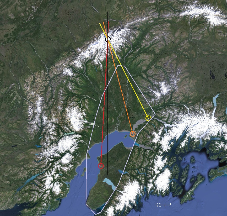
(Fig. 2) Satellite photo of viewing area with locations and line of sight relative to true north centered about the summit of Mt. Denali, black circle, for the dramatic summer solstice backlighting event (TerraMetrics, and Google Map, 2013; adapted, McGraw, 2013).[11] The location and line of sight for the Matanuska River Complex is in yellow (first human activity circa, unknown), the location of the summer solstice video recording site for the city of Anchorage in orange (first human activity circa, 4000 BCE), the location for the town of Kenai in red (first human activity circa, 1000 BCE),[12] true north axis indicated with the black line. The estimated boundary area for viewing the event being noted in light purple. The estimated area covering some 450+ square miles (1036+ sq km)(scale 20 mi - 20 km).
The 3 hour 18' minute video recording of the summer solstice backlighting event of Mt. Denali (Mt. McKinley) (Vid. 1), as seen from Anchorage Alaska (Fig. 10) from the top of McKinley Tower, recorded on the night of 17-18 Jun 2013, starting at 11:50 AKDT and ending at 02:08 AKDT which was 171' minutes prior to local celestial midnight (anti meridian) running till 37' minutes past local celestial midnight at 01:41 AKDT, or 07' minutes past local solar midnight which occurred at 02:01 AKDT.[32] The actual moment of summer solstice for Anchorage Alaska in the year 2013 being 21:04 AKDT, 20 June while the Sun was still above the horizon.
[33]
(Fig. 11) Photo of Mount McKinley massif (Mt. Denali) as seen from the roof of McKinley Tower, Anchorage Alaska, on 15 Sep 2013 at 14:37 AKDT (Borealis Broadbrand, 2013; adapted McGraw, 2013).[34]
Using dead reckoning (visiable landmarks), the calculated field of view (FOV) for the video camera being 60o degrees wide spanning from approximately 308o to 008o degrees in azimuthal bearing (Fig. 12).
[35]
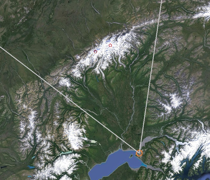
(Fig. 12) Aerial satellite photo (Google Map, 2013; adapted, McGraw, 2013) representing the estimated field of view indicated with grey lines for the summer solstice video recorded from the roof of the McKinley Towers in downtown Anchorage.[36] Towards the upper left center of the frame is Mt. Foraker, marked with in maroon pentagon, with Mt. Denali at upper center indicated with a red pentagon.
Weather conditions in Anchorage preventing the viewing of a cloudless and transparent horizon for anlysis on the actual night of the summer solstice for the duration of the event, and critical factor needed for timing and confirming the azimuthal location of the Sun at the moment of sunset, this visual information being used to help more precisely estimate the location and path of the Sun's motion below the horizon.
[37]
(Vid. 1) Video (8.5 MB wmv) (McGraw et.al., 2013) of the midnight summer solstice event as seen from the roof of McKinley Towers in downtown Anchorage (Borealis Broadbrand, 2013). The video being composed of still frames captured at one minute intervals facing in the direction of the North West horizon, 2 days prior to the start of summer. Horizon conditions needing to be sufficiently free of clouds, not permitting for full length, non interrupted, backlit event video for 9 - 4 and 2 days prior to the first day of summer to 5 days after solstice. The elpase time of the video, 3 hours 18' minutes beginning at 22:50 local time (AKDT), or 52' minutes prior to local sunset at 00:42. Celestial midnight (anti meridian) and far more relevant of the two midnight events for the inhabitants of the area for stars at night in the summer, being difficult to observe during this time of year to mark a moment in seasonal time, occurring at 01:41 AKDT followed by local solar midnight (anti-culmination) at 02:01. The video camera lens horizontal field of view being 60o degrees.
The Sun in elevation at local celestial midnight situated approximately -5o below the horizon and azimuthally 14o degrees east of Mt. Denali, at local solar midnight, and not particularly relevant though shared for the sake of completeness approximately -5o30' below the horizon and 20o degrees to the east. Because of the unusually protracted nature of this solstice event, the Sun being sufficiently close in time and position to local midnight. Other locations withing the viewable area reducing this error to zero.
[38]
[39]
(Fig. 13, upper) Star chart looking north from Anchorage Alaska for the date 17-18 June 2013, using epoch 2000.0 data, of the setting Sun on the horizon and represented as a yellow circle (Stellarium, 2013; adapted, McGraw, 2013). Local sunset time being 23:42 AKDST time (xxxx , 2013), last visibility 23:41 AKDT.[40] (Fig. 14, lower) Star chart looking north from Anchorage Alaska for the same day as above, indicating the location of the non visible, post set Sun along the Northern horizon and represented as a red circle (Stellarium, 2013; adapted, McGraw, 2013), celestial (anti meridian) midnight occurring near 01:41 AKDT with local solar (anti culmination) midnight occurring at 02:01 AKDT (xxxx , 2013).[41]
[42]
[43]
(Fig. 15, upper) Star chart looking north from Anchorage Alaska for 17-18 Jun, the year 4000 BCE, using epoch 2000.0 data for the setting Sun on the horizon and represented as a yellow circle (Stellarium, 2013; adapted, McGraw, 2013).[44] Local sunset time being approximately xx:xx AKDT. (Fig. 16, lower) Star chart looking north from Anchorage Alaska for the same day as above, indicating the location of the non visible, post set Sun below the horizon and represented as a red circle (Stellarium, 2013; adapted, McGraw, 2013), celestial (anti meridian) midnight occurring near xx:xx AKDT with local solar (anti culmination) midnight occurring at xx:xx AKDT.[45] The Sun situated approximately xxo degrees below the horizon and xx' minutes east of Mt. Denali. The Sun traveling further east and below the horizon around circa 4000 BCE, implying the summer solstice event, in relation to Mt. Denali occurred closer to local celestial midnight by xx minutes, with the duration time of peak backlight illumination being shorter in length than what is currently seen today.
The midnight backlighting of Mt Denali, thus full night visibility of the mountain massif, most deffiniately not an observable event by the fall equinox (Fig. 17), already diminishing from view at midnight by the begining of August. The duration of time, thus rate at which the illumination of this background scene advances from diminished viewing to clearly viewable back to diminished viewing, the cycle starting from around the middle of spring and completing by the middle of summer, being more abbreviated and rapid during the 3rd - 4th millennia BCE with the Sun placed further in negative elevation from the northern horizon, further within the anti Earth (anti culmination) region.
[46]
(Fig. 17) Mosaic collection of video frames of Mt. McKinley massif near the fall equinox 2013 taken at 21:11 (top) and 22:00 (center) AKDT on the 20th and 06:57 (lower) AKDT on the 24th of September.[47] Note how the massif, at no time during the late night, is backlighted by the Sun.
Compounding the problem of traveling near the polar region during the summer months is that the nighttime sky from near the artic circle and close to the summer solstice, is too bright in light level to easily view stars in the sky. The inability to directly view such objects and basic bearing indicators such as the north star, Polaris (alpha Uras Major), a star with a brightness of magnitude +1.5,[xx] hence easy to view even by those needing minor vision correction and or older in age (pupal dialation limitations),[xx] adversly impacting the ablity of neolithic people to obtain a sense of direction. The aditional problem of increased number of overcast or cloudy days for the northern region,[xx] futher limiting the ablity of travelers to ganner a sense of direction by using just the Sun and shadow stick (gnomon) method to extrapolate east and west, motivating these people to seak other means for obtain direction headings. The shadow stick method for obtaining north-south, east-west bearing being more difficult in the northern latitudes with the increased incident angle of the Sun relative to the surface along with shadow path distortion produced from the curvature of the Earth.
The high, amibent illumination level of the southern night sky near Anchorage, being easy to notice from the breif video below (McGraw et. al., 2016) and reciprocation of the northern backlighting of Denali mastiff. The video being assembled from a collection of still images taken ~1 minute apart, spanning 2 hours 16 minutes, as seen from a vantage point near Eagle River, Alaska, close to the base of Mount Baldy.[xx] The first quarter Moon, being just to the south wast when first visable at the top of the video frame, setting towards the western horizon (right). During this near local midnight event, no stars and associated with winter constellation such as Gemini, Auriga, Orion, Canis Major, each of these constellation being composed of bright +1st magnitude (visual, Mv) stars or brighter [xx] nor any bright planets during this viewing, being visible in the background. It being possible if orbit condition permit to see Venus and perhaps Jupiter under such bright sky conditions. The brightest star in the sky, with a visual magniude -1.46 such as Sirius,[xx] if present would have been visible to the unaided (naked) eye and if in the camera field of view, perhaps within the dynamic range of the recording digital sensor.
[xx]
(Vid. 2) Video (826 KB mp4)(McGraw et. al., 2016) of the setting first quarter Moon as seen from Eagle River, Alaska near the base of Mt Baldy, two days (weather limited) past the summer solstice.[xx] The video and captured near the brightest hours of the night, commencing just prior to local midnight, starting at 23:19 AKDT on 22 Jun 2015 and ending at 01:35 AKDT on 23 June 2015 for a total duration of 2hr 16' min. The background brightness of the night ski near the time of the summer solstice being too intense in level to view +2 magnitude stars or less. In addition, not possible to view the high in the sky, +1.98 visual magnitude north star, Polaris (alpha Ursa Minor)[xx] to obtain a north-south bearing for course guidance and navigation.[xx]
An equally intriguing possible viewing location of the summer solstice backlighting even of Mt. Denali, and yet to be determined if such sighting is possible, though from cartographical information appears to be well within reason, being the near perfect north south alignment between Mt. Denali and the town of Kenai Alaska , on the western shores of Kenai Peninsula (Fig. 18).[48]
The region surrounding Kenai Alaska estimated to having been inhabited by humans for 3,000 years (1000 BCE). The distance separating Mt. Denali from Kenai being ~173 miles (278 km). The true north error with respects to Mt. Denali being off by only ~5o degrees, the longitude error being 13' minutes 20" seconds or ~15.3 miles (24.6 km) over a baseline of 173 miles.[49] Traveling inland 15.3 miles east toward the mountains of Kenai National Wildlife Refuge in the vicinity of the town of Sterling, this area perhaps providing a more advantageous view of Mt. Denali during solstice, reducing the true north alignment error to zero.
[50]
(Fig. 18) Aerial satellite photo (Google Map, 2013; adapted, McGraw, 2013) showing the yet to be determined though very possible solstice alignment, one that is nearly perfectly north south aligned between Mt. Denali and the town of Kenai Alaska.[51]
Such line of sight distance of 173 miles being well within reason, as the volcanic peak of Mauna Kea 13,803' ft (4,207 m), on the Big Island of Hawai`i at a linear distance of 212 miles (341 km)[52] is on clear day, visible across the water from the city of Honolulu on the Island of Oahu.
 [7]
[7]
 [10]
[10]
-15sep2013.jpg) [33]
[33]
 [35]
[35]
 [39]
[39]
-mosaic_20-24sep2013-b.jpg) [46]
[46]